Geoapify Map Generator
About
Generates map images from geographic coordinates using Python libraries for geocoding and visualization tasks.
Details
- Repository
- burningion/geoapify-mcp
Explore

Setting up with Highlight
This MCP is not yet compatible with Highlight’s one-click setup. However, you can still use it with Highlight by following these steps:
- Download and install Highlight from highlightai.com/download
- Navigate to the plugins tab and select "Add Custom Plugin"
-
Configure the plugin with the settings below
Plugin Name
Geoapify Map GeneratorCommand (node, npx, python, etc.)uvArguments-
Argument 1
--directory -
Argument 2
/PATH/TO/THIS/REPO -
Argument 3
run -
Argument 4
--with -
Argument 5
fastmcp -
Argument 6
--with -
Argument 7
requests -
Argument 8
--with -
Argument 9
folio -
Argument 10
--with -
Argument 11
selenium -
Argument 12
--with -
Argument 13
pillow -
Argument 14
fastmcp -
Argument 15
run -
Argument 16
/PATH/TO/THIS/REPO/server.py
Environment-
GEO_APIKEY
YOURAPIKEY
Please refer to the README for specific instructions on how to obtain API keys or other required environment variables.
-
Argument 1
- Enable "Start Automatically" if you want the plugin to start when Highlight launches





From the repository
You'll need to get an API key from Geoapify, and set it as an environment variable named GEO_APIKEY.
Your claude_desktop_config.json will look like this after:
"MCP Map Demo": {
"command": "uv",
"args": [
"--directory",
"/PATH/TO/THIS/REPO",
"run",
"--with",
"fastmcp",
"--with",
"requests",
"--with",
"folio",
"--with",
"selenium",
"--with",
"pillow",
"fastmcp",
"run",
"/PATH/TO/THIS/REPO/server.py"
],
"env": {
"GEO_APIKEY": "YOURAPIKEY"
}
}
You'll notice we include all the dependencies in our args.
Get GPS Coordinates
can you create a geojson of the following locations including their gps coordinates: 179 avenue du Général Leclerc, côté Rive Gauche
158 avenue du Général Leclerc, côté Rive Droite à l'angle de la rue Jules Herbron
112 avenue du Général Leclerc, côté Rive Droite
34 avenue du Général Leclerc, côté Rive Droite
En face du 57 rue Gaston Boissier, à côté de la borne
Route du Pavé de Meudon - à côté du chêne de la Vierge
6 avenue de Versailles (près du centre aquatique des Bertisettes)
3 places sur parking de la rue Costes et Bellonte
Rue Joseph Chaleil
18 rue des Sables – à côté de la crèche
25 sente de la Procession
33 rue Joseph Bertrand
Place Saint Paul
Place de la bataille de Stalingrad
Placette croisement avenue Pierre Grenier / avenue Robert Hardouin
107 avenue Gaston Boissier (en face de la caserne des pompiers)
Result: Attached JSON file
Returns a GeoJSON file.
Create a Map Image
can you create a map from my attached geojson file?
Result: 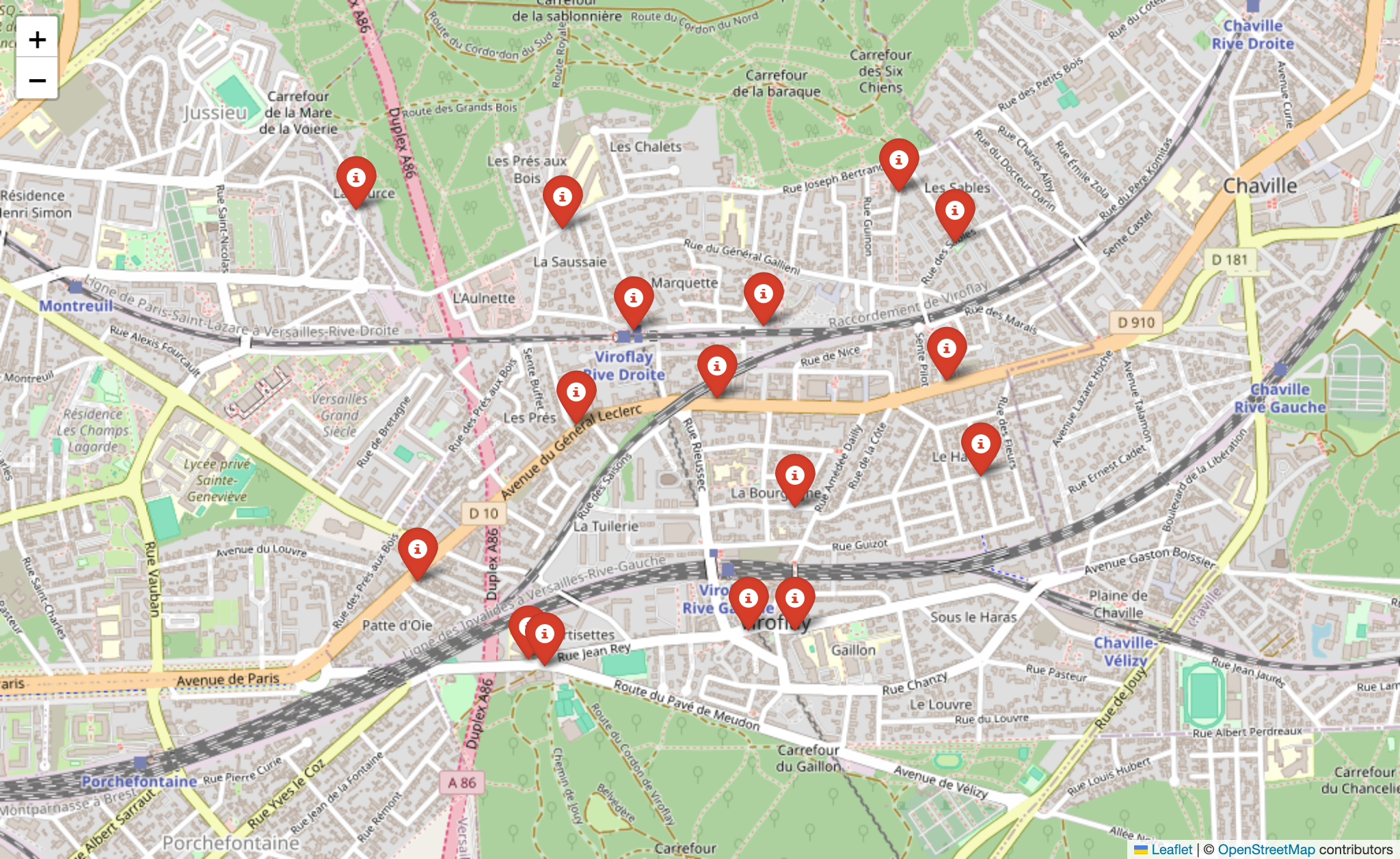
get_gps_coordinates
Used to get GPS coordinates from the API for creating GEOJSON.
create_map_from_geojson
Create a map image from a GeoJSON file and display it. Note: Showing only works on MacOS.
get_gps_coordinates
Used to get GPS coordinates from the API for creating GEOJSON, etc.
create_map_from_geojson
Create a map image and show it. (Showing only works on MacOS for now.)
Claude Desktop / Cursor
Paste into your MCP client config file to install this server.
{
    "mcpServers": {
        "geoapify map generator": {
            "env": {
                "GEO_APIKEY": "YOURAPIKEY"
            },
            "args": [
                "--directory",
                "/PATH/TO/THIS/REPO",
                "run",
                "--with",
                "fastmcp",
                "--with",
                "requests",
                "--with",
                "folio",
                "--with",
                "selenium",
                "--with",
                "pillow",
                "fastmcp",
                "run",
                "/PATH/TO/THIS/REPO/server.py"
            ],
            "command": "uv"
        }
    }
}Linux
{
"env": {
"GEO_APIKEY": "YOURAPIKEY"
},
"args": [
"--directory",
"/PATH/TO/THIS/REPO",
"run",
"--with",
"fastmcp",
"--with",
"requests",
"--with",
"folio",
"--with",
"selenium",
"--with",
"pillow",
"fastmcp",
"run",
"/PATH/TO/THIS/REPO/server.py"
],
"command": "uv"
}Macos
{
"env": {
"GEO_APIKEY": "YOURAPIKEY"
},
"args": [
"--directory",
"/PATH/TO/THIS/REPO",
"run",
"--with",
"fastmcp",
"--with",
"requests",
"--with",
"folio",
"--with",
"selenium",
"--with",
"pillow",
"fastmcp",
"run",
"/PATH/TO/THIS/REPO/server.py"
],
"command": "uv"
}Windows
{
"env": {
"GEO_APIKEY": "YOURAPIKEY"
},
"args": [
"--directory",
"/PATH/TO/THIS/REPO",
"run",
"--with",
"fastmcp",
"--with",
"requests",
"--with",
"folio",
"--with",
"selenium",
"--with",
"pillow",
"fastmcp",
"run",
"/PATH/TO/THIS/REPO/server.py"
],
"command": "uv"
}Geoapify MCP Server
Convert addresses into GPS coordinates for mapping, and optionally create an image of those coordinates using the Geoapify server.
Installation
You'll need to get an API key from Geoapify, and set it as an environment variable named GEO_APIKEY.
Your claude_desktop_config.json will look like this after:
"MCP Map Demo": {
      "command": "uv",
      "args": [
	"--directory",
        "/PATH/TO/THIS/REPO",
        "run",
        "--with",
        "fastmcp",
        "--with",
        "requests",
        "--with",
        "folio",
        "--with",
        "selenium",
        "--with",
        "pillow",
        "fastmcp",
        "run",
        "/PATH/TO/THIS/REPO/server.py"
      ],
      "env": {
        "GEO_APIKEY": "YOURAPIKEY"
      }
    }
You'll notice we include all the dependencies in our args.
Tools
get_gps_coordinates
Used to get GPS coordinates from the API for creating GEOJSON, etc.
create_map_from_geojson
Create a map image and show it. (Showing only works on MacOS for now.)
Example Usage
Get GPS Coordinates
can you create a geojson of the following locations including their gps coordinates: 179 avenue du Général Leclerc, côté Rive Gauche
158 avenue du Général Leclerc, côté Rive Droite à l'angle de la rue Jules Herbron
112 avenue du Général Leclerc, côté Rive Droite
34 avenue du Général Leclerc, côté Rive Droite
En face du 57 rue Gaston Boissier, à côté de la borne
Route du Pavé de Meudon - à côté du chêne de la Vierge
6 avenue de Versailles (près du centre aquatique des Bertisettes)
3 places sur parking de la rue Costes et Bellonte
Rue Joseph Chaleil
18 rue des Sables – à côté de la crèche
25 sente de la Procession
33 rue Joseph Bertrand
Place Saint Paul
Place de la bataille de Stalingrad
Placette croisement avenue Pierre Grenier / avenue Robert Hardouin
107 avenue Gaston Boissier (en face de la caserne des pompiers)
Result: Attached JSON file
Returns a GeoJSON file.
Create a Map Image
can you create a map from my attached geojson file?
Result:
LICENSE
MIT
Sign in to leave a review
Use Google, GitHub, or an email account so ratings stay tied to real people.
No reviews posted yet.